
Garmin eTrex SE
4.2Editor score
168 hour battery life
Multi-GNSS support
Water resistant design
Navigating the rugged terrain of the Appalachian Trail requires reliable technology to ensure safety and efficiency. A dedicated GPS device offers precision that smartphones often lack in remote areas with poor signal coverage.
We analyzed ten top-rated handheld GPS units and guides based on durability battery performance and mapping capabilities. Each product was evaluated against specific criteria relevant to long-distance hikers and thru-hikers.
This guide highlights standout features and potential trade-offs for every option listed. Prices and availability may change frequently so verify current details before making your final purchase decision.
4.2Editor score
4.3Editor score

4.6Editor score
As an Amazon Associate we earn from qualifying purchases.
This table provides a side-by-side comparison of all ten selected products to help you identify the most suitable device for your specific hiking needs and preferences.





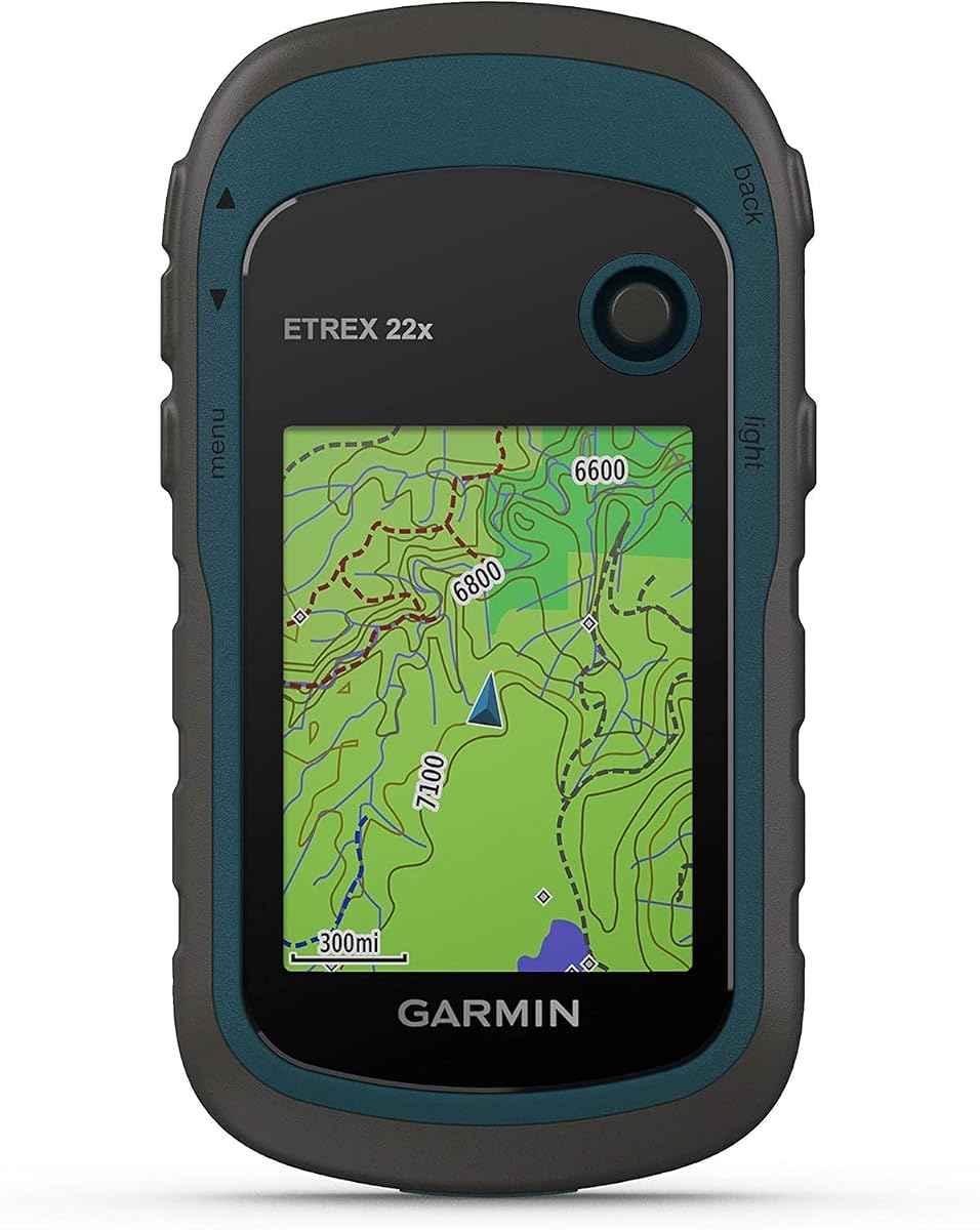
The Garmin eTrex 22x stands out as a top choice for hikers seeking a balance of performance and value. Its high rating reflects consistent reliability in the field across various terrains and weather conditions encountered on the Appalachian Trail.
We may earn a commission when you buy through this link, at no additional cost to you.
This device features a preloaded TopoActive map set which provides routable roads and trails essential for navigation. The sunlight-readable color display ensures you can track your position clearly even during midday summer hikes when the sun is brightest.
While it lacks some advanced sensors found in higher-end models like the barometric altimeter the battery life remains robust at up to twenty-five hours. This duration is sufficient for most day hikes and multi-day sections without needing immediate recharging.
Hikers planning extensive thru-hikes will appreciate the eight gigabytes of internal memory combined with a micro SD card slot for additional maps. It is a dependable companion for those prioritizing core navigation features without unnecessary complexity.
Dual satellite support ensures you maintain a fix even in dense forest canyons typical of the Appalachian Trail.
Physical buttons allow for easy operation even when wearing thick winter gloves or dealing with wet conditions.
We may earn a commission when you buy through this link, at no additional cost to you.
The Garmin eTrex 32x builds upon the foundation of its predecessor by adding critical sensors for advanced navigation. It is ideal for hikers who need elevation data and precise heading information without relying on smartphone applications.
We may earn a commission when you buy through this link, at no additional cost to you.
Its 3-axis compass and barometric altimeter allow for accurate tracking of elevation changes and direction even when stationary. These features are particularly useful on the Appalachian Trail where elevation varies significantly across mountain passes and valleys.
While the price is higher than the 22x model the additional functionality justifies the cost for serious trekkers. The preloaded maps and expandable memory ensure you have all necessary data for diverse trail conditions.
This device remains a premium choice for those who value traditional navigation tools combined with modern GPS accuracy. It offers a complete package for anyone seeking a self-reliant navigation system for long-distance hiking.
The barometric altimeter provides precise elevation readings crucial for monitoring progress on steep ascents.
A 3-axis compass ensures accurate direction reading without needing to move the device rapidly.
We may earn a commission when you buy through this link, at no additional cost to you.
The Garmin eTrex SE offers an impressive balance of features and affordability making it a top contender for budget-conscious hikers. Its extended battery life is a standout feature that reduces the need for frequent recharging on long trails.
We may earn a commission when you buy through this link, at no additional cost to you.
With up to one hundred sixty-eight hours of battery life in standard mode this device supports long duration trips easily. Multi-GNSS support ensures you get a lock from multiple satellite systems improving accuracy in challenging environments.
Connectivity with the Garmin Explore app adds modern convenience for trip planning and map management. You can manage data wirelessly which is a significant advantage over older models that require cable connections.
For hikers who need reliable navigation without spending a fortune the eTrex SE is an excellent choice. It delivers core functionality and robust battery performance that fits well into any budget-friendly hiking gear list.
The standard mode battery life allows for week-long trips without needing to carry extra power banks.
Wireless updates keep your device current with the latest map data and software improvements.
We may earn a commission when you buy through this link, at no additional cost to you.
This handheld GPS offers a large screen and generous memory which are practical features for viewing detailed maps. The USB rechargeable battery adds convenience compared to traditional AA battery models that require carrying spares.
We may earn a commission when you buy through this link, at no additional cost to you.
With thirty-two gigabytes of internal memory you can store extensive map data without needing external cards immediately. The larger display helps with readability in complex terrain where zooming in is frequently necessary.
While the user rating is lower than major brands it still provides essential features like Multi-GNSS support and IP66 waterproofing. It represents a viable alternative for those seeking specific hardware features at a competitive price.
Consider this option if screen size and memory are your top priorities over brand reputation. It can serve as a backup device or primary tool depending on your tolerance for potential software limitations.
The 3.2 inch screen offers more visual space for navigating complex route intersections.
USB-C charging aligns with modern devices reducing the number of cables needed in your pack.
We may earn a commission when you buy through this link, at no additional cost to you.
The Garmin GPSMAP 65s brings advanced multi-band technology to the handheld category ensuring superior accuracy. This is especially beneficial in areas with dense tree cover or deep canyons common on the Appalachian Trail.
We may earn a commission when you buy through this link, at no additional cost to you.
Its larger 2.6 inch display provides a clearer view of maps and data fields which helps during quick checks. The robust build quality and high user rating suggest it can withstand the rigors of daily use.
Features like the barometric altimeter and compass are integrated seamlessly into the interface. You get a professional-grade tool that supports precise navigation without compromising on durability.
For serious hikers who demand the best accuracy and reliability this model is a strong investment. It delivers high-end features that justify its premium cost for those who hike frequently.
Multi-band technology minimizes signal loss in challenging terrain ensuring you stay on track.
The larger screen makes map details easier to read without squinting or slowing down.
We may earn a commission when you buy through this link, at no additional cost to you.
While not a GPS device this book is an essential companion for planning and understanding the Appalachian Trail. It offers a removable full-size map of the entire trail which is a practical tool for trip logistics.
We may earn a commission when you buy through this link, at no additional cost to you.
The detailed photographs and essays provide a deep appreciation for the history and beauty of the path. This knowledge can enhance your hiking experience by connecting you with the legacy of those who walked before.
Using this book alongside a digital GPS creates a comprehensive navigation strategy. The paper map serves as a reliable backup if your electronic devices fail due to battery issues or damage.
It is highly recommended for anyone preparing for a thru-hike or significant section hike. The visual and textual content serves as both a reference and an inspiration for your journey.
The full-size map is a great tool for laying out routes before departure.
Learn about the history and conservation efforts to deepen your respect for the trail.
We may earn a commission when you buy through this link, at no additional cost to you.
The Foretrex 401 is unique as a wrist-worn GPS which keeps your hands free for climbing or handling gear. Its compact form factor makes it ideal for hikers who prioritize convenience and lightweight packs.
We may earn a commission when you buy through this link, at no additional cost to you.
With HotFix satellite prediction it can acquire a position quickly even in difficult spots. The triple sensor compass and barometric altimeter provide robust navigation data despite its small size.
Audible alarms can alert you to waypoints which is helpful when you are focused on the terrain ahead. This reduces the need to constantly check the screen and ensures you do not miss turns.
While the screen is small it provides the essentials for getting from point A to point B. It is a fantastic secondary device for those who want redundancy without the bulk of a handheld unit.
Wearing the unit on your wrist allows for natural movement without needing to stop and handle a device.
HotFix technology reduces wait times for a GPS fix in challenging environments.
We may earn a commission when you buy through this link, at no additional cost to you.
The eTrex 20x is a classic unit known for its high sensitivity GPS receiver which works well in heavy cover. It includes a worldwide basemap that is useful for basic orientation in remote areas.
We may earn a commission when you buy through this link, at no additional cost to you.
With WAAS enabled and GLONASS support it ensures accurate positioning across different regions. The expandable storage allows you to load additional map details for the Appalachian Trail.
It is a simple and reliable device that focuses on core navigation functions without extra complexity. The water resistant design adds a layer of protection against rain and accidental spills.
For those who prefer a no-frills device that just works this is a solid choice. It remains a dependable option for hikers who value simplicity and established performance.
Support for multiple satellite systems ensures you can track your path reliably.
Water resistance allows you to continue using the device during sudden rain showers.
We may earn a commission when you buy through this link, at no additional cost to you.
This book tells the inspiring story of Emma Gatewood who became the first person to walk the Appalachian Trail three times. It provides a window into the history of hiking and the resilience required for such an endeavor.
We may earn a commission when you buy through this link, at no additional cost to you.
The author used diaries and interviews to create a detailed and authentic account of her journey. This makes the book a valuable resource for understanding the trail from a historical perspective.
While it does not help with physical navigation it helps with mental preparation and motivation. Reading her challenges can prepare you for the difficulties you might face on your own journey.
It is an excellent addition to your reading list before or after a hike. The narrative is engaging and offers a unique perspective on the history of the Appalachian Trail.
Gatewood's story highlights the importance of persistence in completing the Appalachian Trail.
Understand the origins of the trail through the eyes of one of its most famous hikers.
We may earn a commission when you buy through this link, at no additional cost to you.
This guide covers the northeastern states that make up a significant portion of the Appalachian Trail. It offers detailed maps and descriptions for trails in Connecticut Rhode Island New York and Maine.
We may earn a commission when you buy through this link, at no additional cost to you.
The high-quality photographs help you visualize what to expect before you hit the trail. This can be useful for planning acclimatization hikes before starting your main journey.
It serves as a great complement to a GPS device by providing trail descriptions and tips. The regional focus allows you to explore side trails and connections around the main path.
Consider this if you plan to explore the northern section of the trail. It provides the detailed regional context that a generic GPS map might not offer.
The maps in this book offer more specific local features than standard GPS layers.
Photos help you set realistic expectations for the terrain and scenery.
We may earn a commission when you buy through this link, at no additional cost to you.
Selecting the right GPS device involves evaluating several key factors that impact safety and usability on the trail.
Battery life is critical for long-distance hiking on the Appalachian Trail where recharging opportunities are limited. Look for devices that offer at least twenty-five hours of continuous use or those that use AA batteries which are easy to replace in the field.
Prioritize models with high capacity or low power consumption modes to ensure you stay connected throughout your trip.
A clear sunlight-readable display is essential for navigating under a bright summer sun. The screen should be large enough to read maps without squinting but not so large that it adds unnecessary weight to your pack.
Choose a device with a high-resolution color display to distinguish trails and landmarks effectively.
The Appalachian Trail can be muddy and wet so a rugged build is necessary to protect the electronics. Look for devices rated at least IPX7 which means they can withstand immersion in water for short periods.
A rubberized exterior helps absorb shock from accidental drops and enhances grip in wet hands.
Maps are the most important feature of any hiking GPS. Ensure the device comes with preloaded Topo maps that cover the Appalachian Trail region accurately.
Check if the maps are routable so you can get turn-by-turn directions if you lose the trail.
Support for multiple satellite systems like GPS GLONASS and Galileo improves accuracy in areas with obstructed views.
Devices with multi-band technology offer superior precision in dense forests which are common along the route.
Compass and barometric altimeter sensors provide vital data for orientation and elevation tracking.
These tools are particularly useful when visual references are scarce or when navigating through fog.
Wireless connectivity allows for easy map updates and tracking without needing a computer cable.
Look for Bluetooth support to connect with your smartphone for backup navigation options.
Lightweight devices reduce the overall load of your gear which is crucial for long hikes.
A compact form factor ensures the device is portable without being too small to operate easily.
Always charge your device fully before starting your hike and carry extra batteries if possible. Practice using the device at home so you are familiar with all buttons and menu settings.
Keep the device dry by storing it in a ziplock bag or waterproof case when not in use. Avoid leaving it in direct sunlight for extended periods to prevent overheating.
Regularly update your maps and firmware to ensure you have the latest trail data and features. Clean the screen with a soft cloth to maintain visibility and avoid scratching the surface.
While the trail is well-marked a GPS provides an essential safety backup in case you lose the trail or face bad weather. It helps you track your progress and navigate through areas where blue blazes might be missing.
Smartphones are convenient but they have shorter battery life and are less durable than dedicated GPS units. A dedicated device is often more reliable for long hikes where you cannot easily recharge your phone.
You should check for map updates before each major trip to ensure you have the latest trail changes. Most manufacturers release updates regularly so staying current helps avoid navigation errors.
Lithium AA batteries often perform better in cold weather compared to standard alkaline batteries. They also hold a charge longer which can extend your device's runtime on long days.
Yes because the Appalachian Trail involves unpredictable weather conditions including rain and streams. A waterproof device ensures your navigation tool continues to work even when exposed to moisture.
Yes most handheld GPS units rely on satellite signals and do not require cellular networks to function. This makes them ideal for remote areas where phone signals are unavailable or weak.
The Garmin eTrex 22x and eTrex SE offer excellent value and reliability for most hikers needing essential navigation tools.
Prioritize battery life and durability when making your final decision to ensure safety during long sections of the trail.
Verify current prices and availability online before purchasing to get the best deal for your selected model.